Graffiti Abatement Program (Office of Neighborhood Involvement)
ONI's Graffiti Abatement Program works with concerned neighbors and business-owners to identify, report and remove graffiti from public and private spaces.
Notified About
-

-
Se Nehalem St And 72nd Ave Portland, OR - Brentwood-DarlingtonProstitutes on the southwest corner, drug deals on the northwest corner, and graffiti tags daily everywhere. Best place to raise kids, ever!
-

-
 changes at Camille Park ArchivedCamille Park Beaverton, OR - Sellwood-Moreland
Good Morning,
Thank you for your response and I appreciate your willingness to meet and discuss this issue with us. In the spirit of cooperation and compromise, I would like to continue our dialogue regarding the path and bridge with some information here. You state that you would be willing to work diligently to modify the path should concerns arise or problems occur. I believe there are some issues denoted here that may be of import in this project and may warrant modifying plans. I fully understand and accept that the taxpayers and parks administration have spoken and that these items will be built. However, I feel that it is important to share this information with you considering the placement you have chosen. I have to wonder if you are aware of the amount of water that gathers and sits for months here. I wonder if your Management Team is aware of this. As you are off-site, we have the perspective of being here at the park 24/7 and this is what we have observed. This is what we tried to explain on 9/27/11, again in the spirit of cooperation and compromise. With this image of the park in winter below in mind, it hardly seems that the present setting is the best placement for this path and bridge. I am hoping that as you review this information and look at the on-site pictures that you will understand why we have been saying for at least three years to you that this may not be the best placement and hopefully accommodations for more effective placement will be considered for better use. This is a picture from last January. It continues to rain and gather water through June here. There are times when these little ponds freeze as well in the winter. This is where the cutest duck couple lands. Where the bridge is to go, a heron visits and feeds often. This is also the exact path of the flags you have set up to build the path and bridge. Directly to the east is an area that is higher (as shown below) and has more even and level ground that may better accommodate this project. It does not sit underwater during the times that the area shown below do. Therefore, the path would be more likely to be used rather than avoided because of the puddles on the path and the mud gutters that gather at the sides of paths in the rain. This path adjustment would still allow for the bridge to connect both sides and create the loop effect desired.
DSCN0298.JPG
Proposed path and bridge site - JanuaryDSCN7675.JPG
Proposed path and bridge site - SeptemberModified path and bridge.jpg
Detail showing existing camas field (purple) and option for alternative path and bridge placement (green)The Purple dots at the bottom I have added to the map in the Oak Enhancement Area represent a stand of camas lilies that appear in two months in Spring. This field was not mentioned here on this map, so I am not sure you know they exist. This is located in the area behind where I was sitting at the bench when we met and spoke on Tuesday, 9/27/11 on the far western edge of the park..
The Green dots at the top left I have added to the map represent a viable option for an alternate route for the path and bridge, still in keeping with the approved plan for said, that would be on higher and more even ground, not resting in standing water and puddles and creating mud gutters along the path for the greater portion of the year, and it would still connect to the loop and path at the other end creating the desired effect of more contiguous walking space. As it will likely be a bit shorter, there would be savings in supplies, equipment, and manpower to be utilized for the additional aspects of the park that will still need to be funded through to completion.
Option for alternative placement for path and bridge directly to the east of the proposed site.
DSCN0739.JPG
The following are images of the proposed path and bridge area panning from west to east on a dry day in May.
DSCN0732.JPGDSCN0733.JPG
DSCN0734.JPG
DSCN0735.JPGDSCN0736.JPG DSCN0738.JPG
Option for alternative placement for path and bridge directly to the east of the proposed site.
DSCN0739.JPGThis is the site of the bridge.
201589_1814834285629_1083213539_31894147_900327_o.jpgIn the spirit of compromise and working together, I ask that you consider this alternate route based not only on the security issues we expressed to you and the Superintendent of Security Operations and Park Planner, but also based on the fact that this proposed space is largely underwater most of the year and will be inaccessible or undesirable to tread through. There are also ecosystems that exist in the area you intend to use. These are feeding areas for the wetland birds such as ducks and heron as well as hawks and owls who feed on the frogs and rodents here. There is also the issue of rodent control as the predators are pushed out of the park by people in their hunting and feeding spaces. We are already dealing with rats entering into our yard from the park that have been displaced and shaken out due to construction equipment and activity. There is also the aspect of erosion in the area of the path, the areas at the roots of the trees where the path will go through to the bridge, as well as the mud gutters that form alongside every path, further compromising the integrity of the pathway in the long term. the underwater areas also freeze, which can cause cracks and damage to the asphalt path which will need further repair and maintenance. There is also the consideration of maintaining and preserving the existing camas field not mentioned on the map on this northwest side of the park nestled within the oak enhancement area adjacent to the horseshoe pit. I understand and appreciate concerns about invasive species and their removal for the protection of the park. You can likely understand and appreciate that humans are the most invasive species a park has to be concerned about due to their pollution, graffiti, and other behaviors. Having the camas lilies and valuable oak grove kept a safe distance from the people intervening on their growth and environment, they might be able to remain for us all to enjoy longer into the future. People pick the flowers. Dogs run through them. The existing camas field on the map in the west center of the park where the basketball court used to be has shrunk in depth and size over the 8 years I have lived here because it has been mowed and people have walked through to get into the wooded area behind them. Those aren't deer paths. Because there is no reason to go back into the northwest area of the park near our house due to the bogginess of the soil and the barrier of the creek, the camas and oaks have been allowed to grow undisturbed and proliferate. Please also note, these pictures were taken at different times of the year and at different times of day. How many people do you see on any path? This park is not that populated 9 months out of the year, as you can see. Please take that into consideration as well.
When we moved into our house 8 years ago, our neighbors informed us of our role in the park watch they had established. We were told to call the Park Patrol with issues. And we have. We have since learned how long the response time is in general and what their hours of operation are. We learned that we were to call the Beaverton Non-Emergency number after Park Patrol was off duty. We learned that the Police would send someone out if it were an emergency or if they had the availability. We learned that from the time the Park Patrol go off duty at midnight until morning, the park is generally unattended by Parks Patrol or, unless emergency, the Police. We have called and would call Park Patrol more often, but the activity we are referring to occurs after hours when it is late and dark and they are not available to take the call. I know that your focus is largely on the park and activities therein during the daytime and that you may not consider what goes on after dark. There are concerns I don't think you have fully considered. Being that you have no one observing and reporting, we observe and we reported to you what we have learned over eight years of 24/7 observation. We are here 24/7, like the park. I have worked in psych dept at St. Vincent and have had homeless patients tell me some of the parks they stay in. The guy who takes the bottles from our recycling on Thursdays was a patient and told me that he was staying back in the wooded area behind the park. We are trying to communicate to you from a perspective that you may not have considered because it is not part of your job. We were hoping you would take our information and observations to heart as fellow citizens and community members. These are valid concerns.
Please share this with your team. If a picture is worth 1000 words, then I have already said what needs to be said. Please take into consideration moving the path just a bit father to the east, on the higher ground, where it can still have the bridge to attach to the path on the other side and continue the loop as requested by the taxpayers. As a taxpayer and park patron and observer of the park, I hope that you act on this in a manner that serves all the park patrons and our community as a whole.Thank you for your time and due diligence,
Beth Rakoncay
runningmare27@gmail.com"Every great and deep difficulty bears in itself its own solution. It forces us to change our thinking in order to find it." - Niels Bohr
On Wed, Sep 28, 2011 at 3:00 PM, Bruce Barbarasch wrote:Dear Mr. and Mrs. Rakoncay,
Thank you for taking the time to meet with Park District staff on 9/27/11 to discuss your concerns about the path arrangement at Camille Park. We brought back your concerns and discussed them with our Management Team. We understand your concerns a -
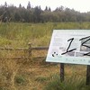 Springwater Corridor Trail Portland, Oregon - Pleasant ValleyOne of Gresham's finest used black spray paint to tag the sign overlooking this scenic meadow area. The sign was also scratched at some point. Anything left out in the open is subject to desecration by ingrates. The photo is a simulation of the damage from memory; wish I'd had a camera.
 -
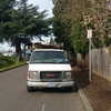
 Abandoned vehicle Archived3421-3429 Southeast 38th Avenue Portland, Oregon - RichmondBlue Chevy van. 80's. Expired tags 2003. Full of junk. Saw tweaked out looking white male and female unloading jugs and hoses. Smells of chemicals. Hasn't moved in one week.
 -
 Abandoned vehicle Archived3421-3429 Southeast 38th Avenue Portland, Oregon - RichmondBlue Chevy van. 80's. Expired tags 2003. Full of junk. Saw tweaked out looking white male and female unloading jugs and hoses. Smells of chemicals. Hasn't moved in one week.
 -
 Post to neighbors Archived3010 Se 36th Ave Portland, Oregon - RichmondAbandoned vehicle. Early 90s Chevrolet pick up. Expired tags. Full of junk and illegally parked.
 -
Neighborhood Graffiti ArchivedNe Halsey And 102nd Ave Parkrose - HazelwoodAnother string of graffiti tagging in my neighborhood: a house, a fence, and a car. I think it's targetted near us because of the dead end street with no street light. The graffiti happened on the "other" dead end of Brazee, next door to my house. The neighbors have agreed to help each other watch, but we haven't caught anyone.
-
 Post to neighbors Archived3431 Se 38th Ave Portland, Oregon - RichmondPeople camping on this street. Garbage and tags are expired. They park this van and sleep in another blue Chevrolet van that someone reported already. Parked in no parking zone.
 -
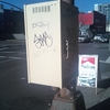 Graffiti on city property Archived1487 Sw Alder St Portland, OR - NorthwestGraffiti on light signal box and parking meter