

Description
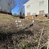
I got lost at this intersection because I followed the trail around the back of the school from the south and intended to turn right at this intersection but turned left because I was unfamiliar with the trail route. This would be a good place for a wayfinding sign like the one pictured, pointing north to Chavis Park, south to McMakin St, and east to Walnut Creek Wetland Center.
a aussi demandé...
Q. What park/greenway is this issue occurring in? If this is on a greenway, please give a mile number or nearest intersection.
A. Little Rock Trail between Bragg St. and McMakin St
A. Little Rock Trail between Bragg St. and McMakin St


9 Commentaires
Clos City of Raleigh 2 (Membre officiel vérifié)
Display Name Blocked (1448257) (Utilisateur inscrit)
Display Name Blocked (1448358) (Utilisateur inscrit)
Display Name Blocked (1447915) (Utilisateur inscrit)
Display Name Blocked (1448545) (Utilisateur inscrit)
Display Name Blocked (1448657) (Utilisateur inscrit)
Display Name Blocked (1448681) (Utilisateur inscrit)
Neighborhood Watch (Utilisateur inscrit)
Display Name Blocked (1450457) (Utilisateur inscrit)